We are experienced surveyors & experts in 3D laser scanning.
Find out moreRequest a quote3D Laser Scanning
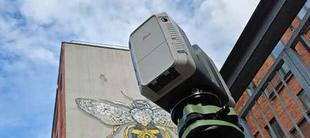
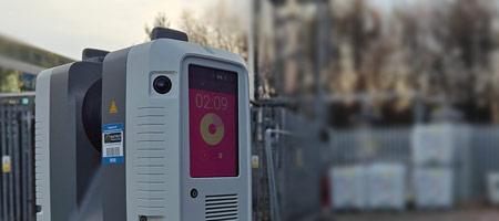
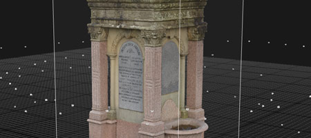
3D Laser Scanning is a non-contact, non-destructive technology that captures the shape and appearance of physical objects or environments using laser beams.
BIM and Revit modelling
3D Laser Scanning is a non-contact, non-destructive technology that captures the shape and appearance of physical objects or environments using laser beams.
Topographical survey
Process that captures and represents the physical features of a specific area, including both natural and man-made elements such as buildings, roads, vegetation, water features, and other significant landmarks.
What we can do for your's company?
We are highly trained and experienced surveyors with a passion to deliver your projects in good timeframe and with the precision required. We understand that the information and output we give is a vital part of any project.
Understand & Quote
First of all, we understand your requirements and get to know the project. We will then provide you with a no obligation quote for our service.
Strategy & Plan
Once we have instruction we will plan the dates and access if required to carry out the service required whilst keeping you up to date on progress.
Project Execution
We will carry out the necessary work required on site and gather the information needed. Once collected, we will use the latest software to produce the final product to your requirement.
Deliver
You will receive the finished piece of work that we carried out that will help you gain new knowledge and deliver your project.
3D Laser Scanning
3D Laser Scanning is a non-contact, non-destructive technology that captures the shape and appearance of physical objects or environments using laser beams.
topographical survey
The survey records the position, size, and elevation of these features relative to a defined control network, ensuring accuracy for design and construction purposes.
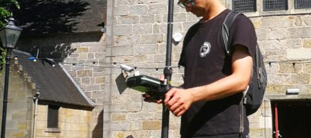
Measured Survey
A measured survey involves taking precise measurements of sites or buildings to create accurate drawings or models at a reduced scale.
Photogrammetry
Photogrammetry is the science and technology of obtaining reliable information about physical objects and the environment through the process of recording, measuring, and interpreting photographic images and patterns of electromagnetic radiant imagery and other phenomena.
BIM and Revit modelling
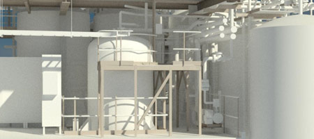
Building Information Modelling (BIM) is a digital process for creating, managing, and sharing information about a built asset throughout its lifecycle, from design and construction to operation and maintenance.
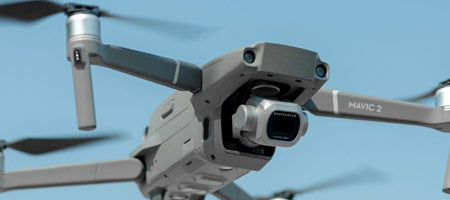
Drone Survey
Drone Survey involves the use of unmanned aerial vehicles (UAVs) equipped with sensors like RGB cameras, multispectral cameras, or LiDAR systems to collect high-resolution aerial data for mapping, analysis, and scientific research.
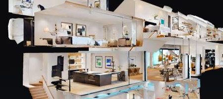
Digital Twin
A digital twin is a virtual representation of a physical object, system, or process that is synchronized with real-world data to accurately reflect its counterpart’s status, behavior, and performance. This synchronization enables real-time monitoring, analysis, and simulation, facilitating improved decision-making and predictive capabilities.
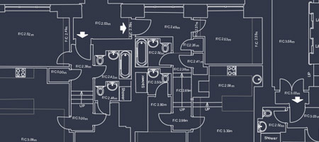
CAD Drawings 2D/3D
In Autodesk software, CAD drawings refer to digital drawings created using Computer-Aided Design (CAD) tools like AutoCAD, Revit, and other Autodesk products. These drawings typically include 2D layouts, 3D models, schematics, and technical illustrations used in architecture, engineering, and construction (AEC), as well as manufacturing and product design.
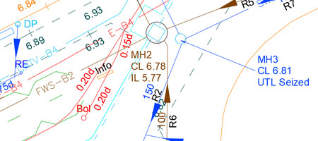
utility Survey
A utility survey is a process of identifying, mapping, and assessing underground and overhead utilities (such as water pipes, gas lines, electrical cables, telecom lines, and sewer systems) within a specific area. It helps in planning construction, excavation, and development projects by minimizing the risk of damaging existing infrastructure.
Mobile Mapping
Mobile mapping refers to the process of collecting geospatial data from a moving platform equipped with various remote sensing devices. These platforms, often vehicles, are fitted with an integrated array of time-synchronized navigation sensors and imaging systems, such as GNSS (Global Navigation Satellite Systems), cameras, radar, laser scanners, or LiDAR (Light Detection and Ranging) sensors.
Matterport definition
Matterport is a spatial data company specializing in creating interactive 3D models of indoor spaces. Founded in 2011, Matterport offers a platform that transforms physical environments into immersive digital twins, enabling users to design, build, operate, promote, and understand various spaces.

Consulting
Consulting is a term for providing business advice on various topics including, corporate strategy, product development, marketing, information technology, and operational improvement.
Find out how we can help you
Speak to the Output Precision team today to find out how we can help with your project.