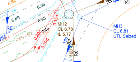
Utility surveys typically use methods such as:
- Ground Penetrating Radar (GPR)
- Electromagnetic Location (EML)
- CCTV Drainage Surveys
- Topographical Mapping
These surveys ensure safety, regulatory compliance, and cost efficiency in construction and maintenance projects. In the UK, utility surveys are guided by British Standards (BS) to ensure accuracy, safety, and compliance with best practices. The key standard for utility detection and mapping is:
BSI PAS 128:2022 – Specification for Underground Utility Detection, Verification, and Location
This Publicly Available Specification (PAS) sets out the methodology for conducting underground utility surveys, including:
- Survey categories (QL-D to QL-A) based on data reliability
- Detection techniques (Electromagnetic, GPR, etc.)
- Data recording and reporting
- Survey accuracy and quality control
BSI PAS 256:2017 – Buried Asset Identification Standards
This standard provides a framework for consistent utility asset data recording and exchange between stakeholders, improving infrastructure management and safety. These standards help professionals carry out accurate and reliable utility surveys to prevent service disruptions and ensure compliance with UK regulations.